He tāone e hāngai ana ki te anamata
A city fit for the future
We’re changing our streets to make it safer and easier for people to get around in climate-friendly ways. The Wadestown Connections project connects Wadestown to the city by making minor street changes to improve the safety and comfort along the route.
These improvements are funded by Waka Kotahi NZ Transport Agency’s Transport Choices programme, formed out of the Emissions Reduction Plan and Budget 2022 to make it easier for people to participate in a low carbon transport system. These essential street changes will make it easier for more of us to be less reliant on our cars and free up space for people who need to drive.
Te ara
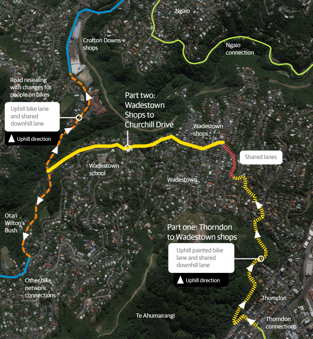
The route – the most important connections
As part of providing a safe and connected citywide bike network, this project is looking at safety improvements to make it easier for more people to get around in low-carbon ways. Wadestown is about a 15-minute ride from the central city.
This project would connect to Thorndon, where street changes have recently been approved to rebalance the street for people walking, biking and on public transport. In the next few years, bike network connections from Wadestown through to Karori and Ngaio are also planned, to make it easier for people to travel between the suburbs.
How improvements in this area will be made
We’re making changes on the first part of the Wadestown route and will be asking for feedback on part two in 2024. We may also introduce a new parking scheme to address parking pressures.
Overall, the changes along these streets will make things safer and easier for people using this busy route and provide more options for how people can get to and from work, school, or tertiary study, drop kids at day care, visit local shops or sports and recreation.
Parking in Wadestown survey
As part of helping us understand the local context of parking in Wadestown, we've been asking people to share how they experience parking in the wider Wadestown area.
We're also keen to hear from residents on Wadestown Road and Blackbridge Road, part two of Wadestown Connections, and their experience of parking on these streets.
The feedback will inform a parking management plan for Wadestown that may result in the introduction of a new parking scheme.
Part one of this project connects from Tinakori Road via Park Street and Grant Road, up Wadestown Road to the Pitt Street intersection.
Our initial investigations showed there were limited options for this section, so we had early discussions with residents in the area before a traffic resolution consultation on proposed changes from 14 August to 28 August 2023.
The proposed plan was to install an uphill bike lane along Park Street, a short section of Grant Road, then up Wadestown Road to the intersection of Wadestown Road and Roscoe Terrace. This proposed change included relocating and removing some parking spaces.
These changes would make it safer and easier for everyone travelling up Wadestown Road, as it would mean people driving wouldn't get stuck behind people biking uphill, and drivers would no longer need to cross the centreline to pass parked cars.
These street changes were approved by Koata Hātepe, Council’s Regulatory Processes Committee, on 5 October 2023 with a number of amendments following community engagement:
- keep the existing lane layout at the Park Street/Tinakori Road intersection and add a green slip lane for people on bikes to get to the advanced stop box at the traffic lights
- install a mobility park outside 97 Grant Road and remove the separated bike lane between 19 Park Street and 107 Grant Road until the mobility park is no longer required
- keep one residents parking space outside 107-109 Grant Road
- change 11.6m of coupon parking to residents parking opposite 111-113 Grant Road
- change one coupon park to residents parking opposite 113 Grant Road (so there will be three residents parking spaces in that area)
- move the proposed 10m of No Stopping lines opposite 75 Wadestown Road further north to be opposite 77 Wadestown Road for better sightlines.
At the same meeting, Koata Hātepe approved street changes on Churchill Drive which will help provide future connections through to Crofton Downs and Wilton, including:
- installing speed humps on the approaches to two pedestrian crossings to slow vehicle speeds
- painting broken yellow lines in the downhill directions on Churchill Drive
- installing uphill bike lanes along Churchill Drive – towards Crofton Downs between Blackbridge Road and Chartwell Drive, and towards Wilton from Wilton Bush Road to Wilton Road.
The changes approved included the following amendments following community engagement:
- reduce the No Stopping lines by 50m to leave space for up to eight cars to be parked on the street near 11 -21 Churchill Drive
- install a 15m section of asphalt footpath so people can get from the track to Izard Park to a safer pedestrian crossing point
- add 32m of No Stopping lines on the eastern side of Churchill Drive, north of Blackbridge Road, to improve safety.
You can find full information about these decisions, including the agenda, minutes, and video of the meeting, on the Council website.
In part two, from Wadestown shops down Wadestown Road and Blackbridge Road, there’s more to explore with the residents and businesses to understand what will best suit this area – so we want to make sure we have the time to build this understanding together.
We don’t expect to change the car parking in the shopping area, as our initial investigations suggest that we can increase safety by reducing vehicle speeds in this area. However, wider parking changes in Wadestown will be part of talking with the community.
Any designs for this area will undergo a full road safety audit, and we will also take our proposed plans to the community for a traffic resolution consultation – likely to be in mid-2024.
In the meantime, we will be raising the two pedestrian crossings in Wadestown village to help slow traffic down past the shops to meet the posted speed limit of 30km/h and make it safer for people to cross the road.
People in Wadestown have told the Council that parking in some parts of Wadestown is under pressure, so we will be working with the community to develop an area-wide parking plan in line with our Parking Policy 2020 that could result in a new parking scheme.
Wellington is expected to grow over the next 30 years, which will dramatically affect the way our city looks, feels, and operates. If we continue at our current rate of car use, our transport network will grind to a halt.
Our goal is to be a city where people of all ages and abilities can move easily and freely in low-carbon ways. These essential street changes will make it easier for more of us to be less reliant on our cars.
We’re changing our streets to make it safer and easier for people to walk, ride, scoot, or use public transport. The changes we’re developing will take time to get used to, but we need to adapt to make sure we can still get around.
In line with Council strategies, policies, and plans, we have developed Paneke Pōneke, a citywide bike network plan. Changes as part of Paneke Pōneke will happen alongside improvements for people walking, scooting, and taking the bus.
Making it safe and easy to bike, walk, and use public transport for everyday trips is key to rapidly cutting emissions in Wellington. It’s vital that we create a connected network, particularly for beginners and less confident riders, as well as people who are experienced riders, so that more of us can get around more often in low carbon ways.
The following strategies, policies, plans and research provide the context for the development of a safe, connected and high-quality bike network alongside other sustainable transport improvements.
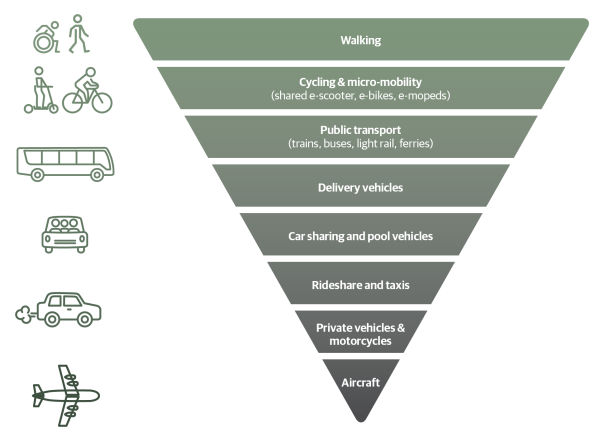
Sustainable transport hierarchy
Our sustainable hierarchy was first adopted in the Urban Growth Plan 2015 (now superseded by the Spatial Plan). The hierarchy prioritises movement by walking, biking, and public transport, so that our city’s streets work better for people.
Paneke Pōneke Bike Network Plan 2022
The bike network will connect suburbs to the city centre and destinations, helping to get people of various ages and abilities from where they live to where they work, study, shop, and play. Paneke Pōneke, Wellington’s bike network plan, was adopted in March 2022.
We consulted on the bike network plan between 2 November – 14 December 2021 as part of the Our City Tomorrow engagement. This engagement also included the draft District Plan and options for mass rapid transit routes through Let’s Get Wellington Moving.
Long-term Plan 2021-2031
The Long-term Plan updated the city outcomes and priority objectives. It also provided $226 million over 10 years to develop a bike network. This is supported by investments in Let's Get Wellington Moving, which will provide for safe biking in the city centre and key corridors connecting to the city centre.
Spatial Plan 2021
The Spatial Plan 2021 provides a blueprint for more housing to accommodate a growing population over the next 30 years. This includes supporting tens of thousands more people to live in the inner-city suburbs and within walking distance of the city centre and rapid transport stops.
A well-connected walking and biking network is key to accommodating more people in the city without adding to car congestion or putting pressure on our bus services.
Greater Wellington Regional Council, Wellington Regional Land Transport Plan 2021
This plan sets out the strategic direction for transport investment across the Greater Wellington region, including targets to reduce transport emissions and increase the proportion of people walking, biking, and using public transport.
Wellington Regional Land Transport Plan 2021
Parking Policy 2020
The Parking Policy provides a framework to guide future decision-making on the management of all Council-controlled parking spaces, and how parking supports achieving the vision for Wellington. The Parking Policy refers to the sustainable transport hierarchy, which gives highest priority to active modes of transport, such as walking, biking, and public transport. This means that when we make decisions on using road space, these active modes take a higher priority to parking.
Te Atakura First to Zero Blueprint and Implementation Plan 2019
We aim to become a net zero carbon city by 2050. Road transport emissions represent 34% of our city’s emissions – making them the single biggest source. Electric vehicles alone can’t solve this problem, given their relative expense. Making it safe and easy to bike, walk, and use public transport for everyday trips is key to rapidly cutting emissions in Wellington.
Te Atakura - First to Zero Blueprint and Implementation Plan 2019
Previous cycling strategic documents
- Wellington Cycle Network Strategic Case 2015: This outlines the challenges related to cycling and how achieving the objectives will benefit Wellingtonians.
- Cycling Framework 2015: This set out a decision-making process for the bike network and how it would be developed. It should be noted that design guidelines for what makes a safe bike lane are continually being developed and we expect to take account of current guidance as we plan improvements.
- Cycling Demand Analysis 2014: This research investigated how different types of cycling infrastructure is likely to affect the numbers of people choosing to cycle in Wellington and assessed the demand for improvements.
Experience the changes, then tell us what you think
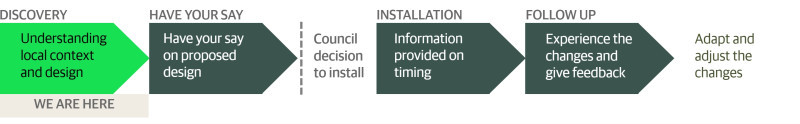
Work to install part one of this route with adaptable materials will start in early 2024.
For part two, we’re working on understanding more of the local context to inform designs. We’ll be able to share designs with the community in mid-2024. We’ll be seeking community feedback before taking the plans to Council for approval. If approved, work would likely begin in late 2024.
Once all the changes are in, we’ll be working hard to gather feedback and data on how it’s going and tweak the designs where necessary. Using feedback and data will inform more permanent changes to follow in the next 5-10 years.
Stay in touch and get involved
We're keen to involve the community as we go, so we will be sending updates when there are opportunities to get involved or have your say.
Got questions about the project? Email us at wadestownconnections@wcc.govt.nz