He tāone e hāngai ana ki te anamata
A city fit for the future
Te Motu Kairangi connections is one of many projects to plan and provide safer and easier options to walk, bike, or bus – so more of us can get places in climate friendly ways.
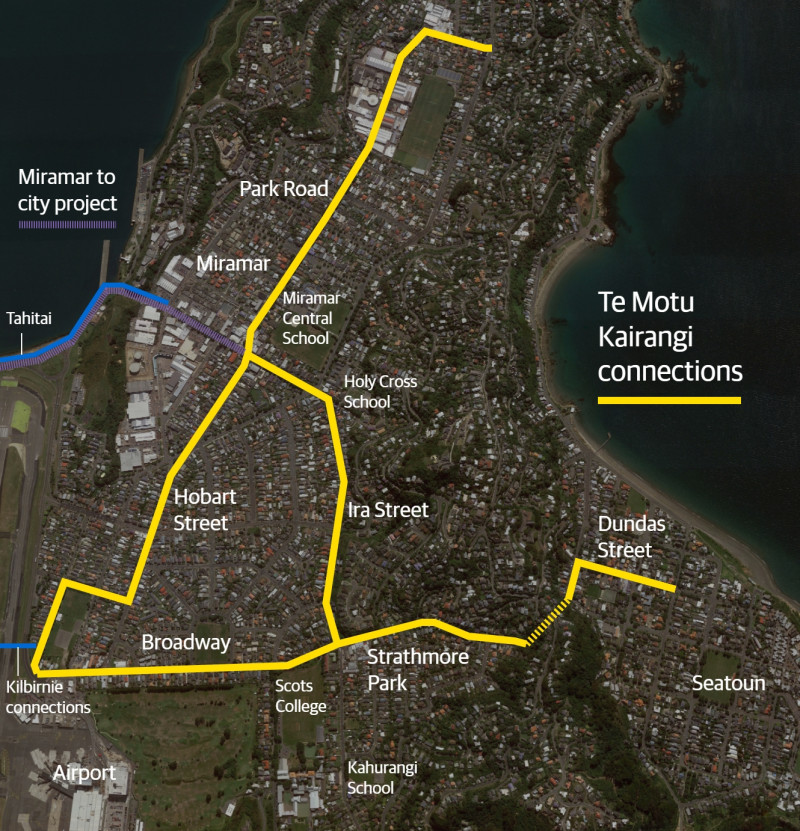
This project involves improvements in Miramar, Strathmore and Seatoun.
Wellington is growing, and more people will be living in apartments or townhouses. Development like this is already happening in parts of the eastern suburbs.
To support this growth, we’re making changes on some streets.
The goal is to be a city where people of all ages and abilities can move safely and easily by bike, bus or on foot, reducing congestion and emissions. These essential street changes will make it easier for more of us to be less reliant on our cars – now and in the future.
Safer bike routes and connections
The routes in this area will connect with and complement bike paths and lanes that are already in place or being installed. They will include improvements for people walking and taking the bus.
They will provide safer, easier, climate friendly ways to get to schools, early childhood centres, cafes and bars, supermarket, the airport, shops and businesses, the Roxy Cinema, library, community centres, parks, playgrounds, and parts of the coast.
Safer connections will also make it possible for more people to bike further afield.
Families, and people of all ages and abilities, are making use of safer connections already available in the east. This project will extend those benefits to more people and places and make this area an even better place to live.
The streets and where we are at
We're beginning to work on designs that we'll be able to share with the community in early 2024.
The four connections (almost 6km in total) are:
- Miramar to the airport via Hobart, Kedah and Miro streets (1.3km)
- Miramar to Strathmore via Miramar Avenue and Ira Street (1km)
- Miramar north including Park and Camperdown roads (1.5km)
- the airport to Seatoun via Broadway, Ferry and Dundas streets (2.1km).
These will complement and connect with the Miramar to the city connection being planned through the Let’s Get Wellington Moving programme.
How to provide input
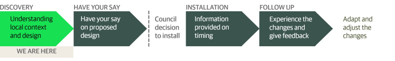
During the project's discovery phase, the team talk with community stakeholders, businesses, and technical experts as we develop detailed route plans. Public consultation on these plans will likely be in the first quarter of 2024.
Our initial baseline survey was completed by 252 residents from mid-August to early October 2023. Information provided through this survey helps inform the route design, and will also be used to evaluate the route’s effect once it’s installed.
If approved, route installation is likely to begin in the second half of 2024, using adaptable materials where possible. We’ll then seek your feedback and collect other information to refine things such as signs, street markings, and parking where necessary.
Stay in touch
We're keen to involve the community as we go, so we will be sending updates when there are opportunities to get involved or have your say.
Got questions about this project? Email the team: tmkconnections@wcc.govt.nz
How we got here
We first consulted on routes in the Miramar area in 2017/2018 as part of a wider eastern connections project. The section of Miramar Avenue between Shelley Bay Road and Tauhinu was completed in early 2022.
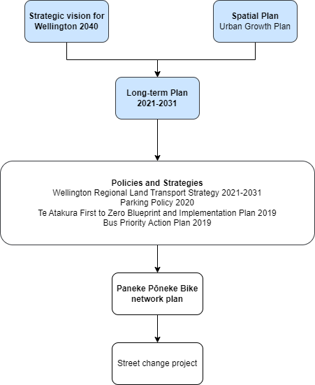
Paneke Pōneke, Wellington's bike network plan, confirmed the routes that would fill the gaps in the network, and better connect the bike paths and lanes that were already in place. The plan was approved in 2022.
Wellington is expected to grow over the next 30 years, which will dramatically affect the way our city looks, feels, and operates. If we continue at our current rate of car use, our transport network will grind to a halt.
Our goal is to be a city where people of all ages and abilities can move easily and freely in low-carbon ways. These essential street changes will make it easier for more of us to be less reliant on our cars.
We’re changing our streets to make it safer and easier for people to walk, ride, scoot, or use public transport. The changes we’re developing will take time to get used to, but we need to adapt to make sure we can still get around.
In line with Council strategies, policies, and plans, we have developed Paneke Pōneke, a citywide bike network plan. Changes as part of Paneke Pōneke will happen alongside improvements for people walking, scooting, and taking the bus.
Making it safe and easy to bike, walk, and use public transport for everyday trips is key to rapidly cutting emissions in Wellington. It’s vital that we create a connected network, particularly for beginners and less confident riders, as well as people who are experienced riders, so that more of us can get around more often in low carbon ways.
The following strategies, policies, plans and research provide the context for the development of a safe, connected and high-quality bike network alongside other sustainable transport improvements.
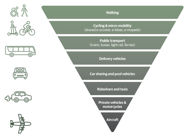
Sustainable transport hierarchy
Our sustainable hierarchy was first adopted in the Urban Growth Plan 2015 (now superseded by the Spatial Plan). The hierarchy prioritises movement by walking, biking, and public transport, so that our city’s streets work better for people.
Paneke Pōneke Bike Network Plan 2022
The bike network will connect suburbs to the city centre and destinations, helping to get people of various ages and abilities from where they live to where they work, study, shop, and play. Paneke Pōneke, Wellington’s bike network plan, was adopted in March 2022.
We consulted on the bike network plan between 2 November – 14 December 2021 as part of the Our City Tomorrow engagement. This engagement also included the draft District Plan and options for mass rapid transit routes through Let’s Get Wellington Moving.
Long-term Plan 2021-2031
The Long-term Plan updated the city outcomes and priority objectives. It also provided $226 million over 10 years to develop a bike network. This is supported by investments in Let's Get Wellington Moving, which will provide for safe biking in the city centre and key corridors connecting to the city centre.
Spatial Plan 2021
The Spatial Plan 2021 provides a blueprint for more housing to accommodate a growing population over the next 30 years. This includes supporting tens of thousands more people to live in the inner-city suburbs and within walking distance of the city centre and rapid transport stops.
A well-connected walking and biking network is key to accommodating more people in the city without adding to car congestion or putting pressure on our bus services.
Greater Wellington Regional Council, Wellington Regional Land Transport Plan 2021
This plan sets out the strategic direction for transport investment across the Greater Wellington region, including targets to reduce transport emissions and increase the proportion of people walking, biking, and using public transport.
Wellington Regional Land Transport Plan 2021
Parking Policy 2020
The Parking Policy provides a framework to guide future decision-making on the management of all Council-controlled parking spaces, and how parking supports achieving the vision for Wellington. The Parking Policy refers to the sustainable transport hierarchy, which gives highest priority to active modes of transport, such as walking, biking, and public transport. This means that when we make decisions on using road space, these active modes take a higher priority to parking.
Te Atakura First to Zero Blueprint and Implementation Plan 2019
We aim to become a net zero carbon city by 2050. Road transport emissions represent 34% of our city’s emissions – making them the single biggest source. Electric vehicles alone can’t solve this problem, given their relative expense. Making it safe and easy to bike, walk, and use public transport for everyday trips is key to rapidly cutting emissions in Wellington.
Te Atakura - First to Zero Blueprint and Implementation Plan 2019
Previous cycling strategic documents
- Wellington Cycle Network Strategic Case 2015: This outlines the challenges related to cycling and how achieving the objectives will benefit Wellingtonians.
- Cycling Framework 2015: This set out a decision-making process for the bike network and how it would be developed. It should be noted that design guidelines for what makes a safe bike lane are continually being developed and we expect to take account of current guidance as we plan improvements.
- Cycling Demand Analysis 2014: This research investigated how different types of cycling infrastructure is likely to affect the numbers of people choosing to cycle in Wellington and assessed the demand for improvements.