Information on this page was correct at the time of consultation, and some of it will now be out of date.  See this page for up to date information

He tāone e hāngai ana ki te anamata
Preparing for the future – providing more options for more people

Swipe through the changes below to see how different people will experience the proposed designs.

Ngā panonitanga I Changes at a glance

The route2x

The route

Key proposed changes include:

  • changes to bus stops, bus lanes, and road layout to improve travel times for buses, and provide for more or longer buses
  • uphill bike lanes to better protect people on bikes. This will also free up general traffic where speed differences are greatest.
  • raising existing pedestrian crossings and installing new crossing
  • two short extensions to existing shared paths
  • improving kerb ramps
  • a new shared path through Appleton Park
  • calmer traffic speeds through retail areas

1 / 5

Changes for walkers2x 1

Changes for pedestrians

Improved and new pedestrian crossings, better kerb ramps, and calmer traffic speeds in retail areas will make journeys around Karori safer and easier for people on foot or with mobility aides and pushchairs.  

Key proposed changes include:

  • raising seven existing zebra crossings along the route
  • two new raised pedestrian crossings, two safety platforms, and new refuge islands near schools and shops
  • calmer vehicle speeds near schools and shopping areas
  • a new shared path through Appleton Park.

2 / 5

Changes for bikes2x

Changes for people on bikes

The proposed changes include bike lanes in uphill sections providing better protection for people on bikes. This will also free up general traffic where speed differences are greatest.

Key proposed changes include:

  • uphill bike lanes along Glenmore Street, Chaytor Street, and Karori Road
  • a shared path through Appleton Park
  • shared traffic lanes in the downhill directions along Karori Road, Chaytor Street, and Glenmore Street
  • additional bike parking at Marsden Village and Karori Park
  • Calmer traffic speeds near shopping areas and schools.

3 / 5

Changes for buses2x v3

Changes for people on buses

Changes to bus stops, bus lanes, and road layout will improve travel times for buses and provide for more or longer buses.

Key proposed changes include:

  • lengthening most bus stops to allow for more or longer buses
  • widening Glenmore Street around the horseshoe bend to better accommodate buses and people on bikes
  • converting five bus stops to in-lane bus stops to reduce delays merging back into traffic, and improve access onto buses
  • exchanging the downhill bus lane on Chaytor Street as far as Curtis Street for an uphill bike lane, which Metlink advises will improve overall bus journey times
  • improving bus stop spacing where they are too close together, for quicker bus journeys.

4 / 5

Changes for cars2x

Changes for people driving

The changes in road layout will make it easier for people driving to share the road safely and travel at safe speeds.

Key proposed changes include:

  • separating bikes on uphill sections, helping buses and cars pass safely
  • calmer traffic speeds near schools and shopping areas by raising seven existing pedestrian crossings, and creating new raised pedestrian crossings, courtesy crossings, and pedestrian refuge islands
  • five in-lane bus stops to help prioritise bus journeys may result in slightly longer travel times
  • significant parking changes along Glenmore Street and Karori Road.

5 / 5

Explore the changes on different streets

Expand All

 Changes in response to stakeholder and community feedback

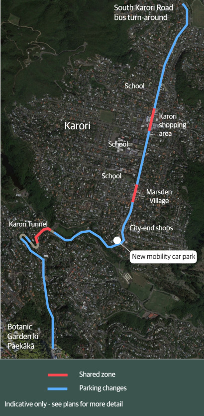
From April 2023, we began engaging with residents, businesses, organisations and schools about planned improvements for pedestrians, people biking and buses along these streets.

As a result of what we’ve heard in these conversations, we have made over 100 changes in our proposed designs, including:

  • Improved kerbs, crossings, raised pedestrian crossings, and other accessibility considerations
  • Additional parking, including residential and mobility parking
  • A median refuge crossing at Karori shopping centre (near the BP)
  • New car parks on road reserve near the Talavera Tennis Club
  • A mobility park on Chaytor Street
  • Additional short-term parking near Marsden School
  • Raised safety platforms across Campbell and Raine streets


As part of our engagement, we’ve worked with groups in the community and stakeholders to refine the proposed designs and hear their views.

These groups included:

  • Churches
  • Emergency services
  • Friends of the Botanic Gardens
  • Karori Business Improvement District
  • Local businesses along the main route
  • Karori primary and secondary schools
  • Karori Residents’ Association
  • Karori residents with accessibility needs
  • Metlink
  • Sports clubs
  • Zealandia

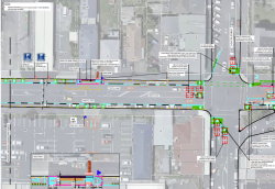
Read a full set of plans and the traffic resolution

You can see the full plans and traffic resolution, as well as other supporting documents.

Aerial image of a technical diagram of an intersection.

Glenmore Street

Glenmore Street by the Botanic Garden ki Paekākā, looking towards Karori

Click and drag to compare

Glenmore Street

Glenmore Street by Crieff Street, looking towards Karori

Click and drag to compare

Appleton Park

Appleton Park by the car park, looking towards Karori

Click and drag to compare

Chaytor Street

Chaytor Street just past Curtis Street, looking towards Karori

Click and drag to compare

Karori Road

Karori Road by the city end shops, view towards Karori

Click and drag to compare

Karori Road

Karori Road by Campbell Street, looking towards Makara Peak

Click and drag to compare

Karori Road

Karori Road by Tringham Street, looking towards Makara Peak

Click and drag to compare